Renowned Standing
Due to the skills we uphold, both large and small roll-out firms want to benefit from our knowledge and expertise.
Your required Blueprint for Efficient and Effective Plumbing

Outsourcing Plumbing Designs and Drawings can be beneficial in many ways. Outsourcing them can help you with
At Gsource Technologies we understand our client’s requirements in detail and provide accurate and efficient plumbing design and drawing solutions for your new or existing construction.
Single-family houses & High rise buildings
Supermarkets & Showrooms
warehouse & Distribution centers
fake
Hotels, Resorts & Restaurants
Your Project is Ready in 4 Easy Steps

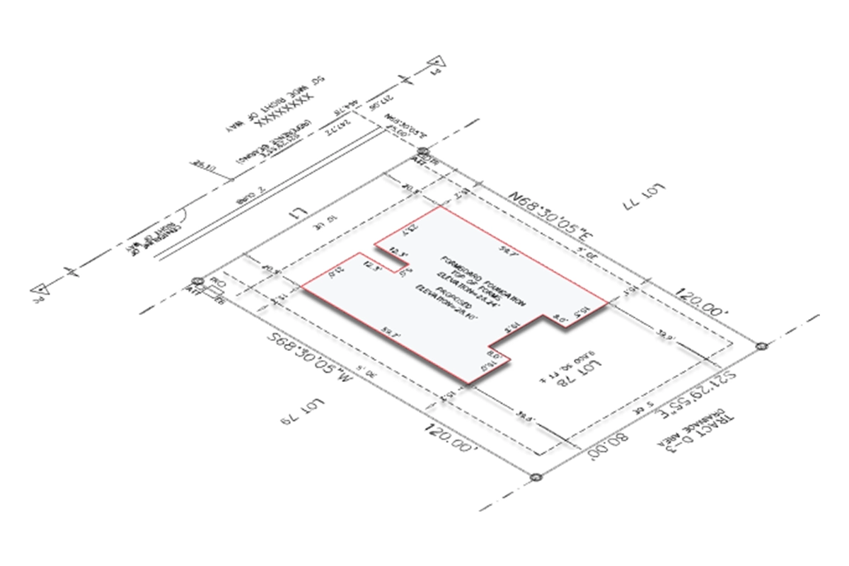
The case study is about boundary surveying for a property, intending to locate the site of any renovations, including a shed. Finding the shed's location was essential to making sure it didn't cross the property line of the neighboring parcel. A thorough boundary survey was carried out in compliance with the client's requirements and local laws. This survey was conducted using on-site surveys and deed records. Its goal was to verify the shed's exact position and highlight all noteworthy upgrades on the owner's land.
Here, we conducted a detailed boundary survey of the land mentioned in the Deed/Title commitment. The details of the land were explained using the Metes and Bounds method in the Deed. To conduct the survey, the documents used were deed legals of adjacent land to verify its boundaries, a detailed and accurate field survey sketch, a .txt or .csv file of point coordinates retrieved from the land survey, and real-time images of the owner’s property for a better understanding of the actual condition. The team utilized CAD drafting software to ensure accurate and efficient results throughout the drafting process.
The property's primary problem was the difference between the deed's legal border and the boundary as established by the survey. Very few reference sites were discovered to be able to precisely determine the boundaries of the area during the first survey phase. A major obstacle was created by this 3-foot difference in the border.
We found errors in the property's legal description after examining the legal descriptions of the relevant property and the nearby parcels. There was a mistake in the legal description as evidenced by the wrong bearings and distances given. We determined the precise boundaries of the property by correcting this inaccuracy in compliance with the adjacent deed.
Later, as the lot and surrounding deeds were being drafted, we saw that there weren't enough restrictions in the area, which made it difficult for us to perform a boundary resolution. To support our claim of rotation, we were encouraged to ask the client for further controls. We rectified the border issues after obtaining the needed data and carrying out additional studies.
To produce an accurate Boundary survey, we investigated several rotation choices using the identified monumentation, took into account the location of modifications, and referred to recent photos. This survey included dimension ties on every side of the land and included information on all improvements, including fences and buildings. Furthermore, from the Title Commitment SBii Exceptions, easements affecting the subject land were located.
To guarantee the integrity and correctness of the survey, a thorough quality check was carried out after the drafting process. To ensure the survey was accurate and free of errors, every detail was carefully examined against a checklist.
The survey revealed that the shed continued one foot onto the adjacent parcel beyond the property border; this was indicated in red on the drawing to indicate the distance to the property line. Upon submission, the client was quickly informed of this disparity.
As a result, the final survey verified that the shed did, in fact, slightly intrude into the neighboring property, which was consistent with the results of the field survey and the documented legal description. For the client's reference, the survey displayed inaccuracy in the legal description.

The case study focuses on creating comprehensive permission paperwork that complies with all laws and requirements for commercial buildings. Floor plans, site plans, and other parts are all included in the file, along with the updated and revised designs. It also included ceiling plans, structural plans, HVAC plans, egress plans, electrical plans, plumbing plans, and more. All of these designs were accurately and completely depicted in the drawings in the file, in compliance with the construction requirements. Every component of the project was thoughtfully incorporated while making sure they complied with all construction codes and regulations.
The scope of work included drawing up a comprehensive site plan that indicated property boundaries, setbacks, and the locations and sizes of all planned structures. A description of the locations of doors and windows, measures, and other pertinent information was also included in the floor plans, along with significant remarks regarding the floors. To provide a comprehensive understanding of the building's materials, construction process, and various levels, sections and comprehensive information were also presented.
The main challenge was the unclear drawings with poor quality of input. The work that was to be done could not be recognized due to these drawings. Also, the measurements weren’t enough and the hand-written notes were hard to understand.
We developed a thorough grasp of the project requirements after thoroughly reviewing the inputs that were provided. This allowed us to modify our efforts properly. A CAD design approach was used to meticulously draw the plans. To find and fix any little flaws, extensive quality control was used.
To make sure there were no discrepancies, these designs and the components they included were carefully inspected. The quality and precision of the drawings were also verified by this method.
Following our careful review of all necessary conditions, we carefully created a complete set of permission documentation. These records are essential to getting the project approved. They provided all the facts, specifications, and specifics required by regulatory bodies to examine and evaluate the suggested plans. Our rigorous approach ensured that all project details were sufficiently recorded, resulting in a clear and comprehensive permit application procedure. With the help of this painstakingly drafted permission paperwork, we were prepared to proceed with the approval procedure and start the project.
Due to the skills we uphold, both large and small roll-out firms want to benefit from our knowledge and expertise.
We use high-tech solutions to understand the design and construction requirements for the Mechanical HVAC systems.
We have an R&D team that can handle the vast data collection, which can feel like a task for other companies.
Timely actions and efficient outputs minimize delays, maximize productivity & ensure prompt mechanical HVAC drawing and design service for our clients.
The data we use to create topographic maps, volume calculations, and distance measurements provide results to the point.
The experience that our team holds is what sets us apart. With training programs, our team of 300 members can deliver top-tier results laid over a 30,000-square-foot Class A Office space.
We are active members of national and international surveying, architectural, engineering & geospatial organizations.
As a service provider, we’ve supported and served companies across the US. Our dedication produces excellent quality that propels industry success.
(Enter captcha image text in box)
At Gsource Technologies, we’re ready to help! Tell us what you need, and we’ll connect you with the right experts.